
Computer science
14 March 2023
The counting of nine billion trees could help manage climate credits and nature restoration
Climate
Researchers from the University of Copenhagen and NASA have developed a method that has now mapped several billion trees and their carbon uptake in Africa’s Sahel. In the future, the method could be used to monitor whether climate credit purchases have a positive effect on the number of trees and whether nature restoration is working.

The purchase of indulgences for CO2 emissions is gaining steam among global corporations. Carbon offset credits allow companies to emit a given amount of CO2 in exchange for the greenhouse gas being neutralized elsewhere, in the form of trees planted or left unfelled.
But with billions upon billions of trees across the planet, keeping track of how many are added and how many are disappearing is tough, to say the least. Now, researchers from the University of Copenhagen’s Department of Geosciences and Natural Resource Management and Department of Computer Science, in collaboration with the American space agency NASA, have pioneered a method that makes it possible to count the number of trees across vast swaths of land and calculate how much carbon is sequestered within each tree.
The study has just been published on the cover of the scientific journal, Nature. The method allowed the researchers to count 9.9 billion trees and measure how much carbon is stored in the semiarid Sahel, a belt of land stretching across Northern Africa, from the Atlantic to the Red Sea. The region covers roughly 10 million square kilometers.
According to Professor Rasmus Fensholt, who played a key role in the research, the new method can be an important tool for companies when they and others want to pay for their emissions – either in the form of newly planted trees or by paying farmers not to cut down trees on their land.
"There are many indications that carbon credit trading will become more and more extensive in the future – not just for earth's forests, but for billions of trees beyond forests. Therefore, it is critical for us to be able to monitor whether carbon trading reflects the actual number of trees in nature and whether it has a positive effect on climate. This is what we are coming with a solution to," he says.
A 300,000-piece satellite image puzzle
Collaborating with NASA, the researchers gained access to 300,000 ultra-high-resolution satellite images of Africa’s Sahel region. The images were reviewed and pieced together in a mosaic that shows the number of trees from above. Using artificial intelligence, they then trained one of NASA's supercomputers to identify individual tree species – for example, acacia based on their flat crowns.
"Our study demonstrates that deep learning techniques can revolutionize the global mapping of individual trees and their biomass. Our artificial neural networks learn to extract complex patterns from large amounts of satellite images, allowing for more accurate and efficient identification of individual trees and subsequent estimation of their biomass," says professor Christian Igel, Department of Computer Science.
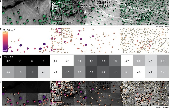
The mapping shows that the Sahel, one of the world's driest regions without being outright desert, is home to nearly 10 billion trees. These trees currently store 840,000,000 tons of carbon according to the researchers' measurements, a number based on the weight of individual trees.
"We have done a lot of fieldwork, weighing trees when they are cut down to collect data on the amount of carbon they contain. We combined this with the satellite images of the number of trees and the size of individual tree crowns and fed it all into a larger model," explains Fensholt.
About the study
- In a new study published in Nature, researchers from the University of Copenhagen’s Department of Geosciences and Natural Resource Management and Department of Computer Science, together with a number of international research institutions, mapped 9.9 billion trees in North Africa’s Sahel, one of Earth's driest regions.
- The Sahel stretches across the south-central latitudes of Northern Africa, from the Atlantic Ocean in the West to the Red Sea in the east, covering an area of 10 million square kilometers.
- The researchers also calculated the amount of carbon stored by the region’s trees: 840,000,000 tons.
- The study was carried out by compiling more than 300,000 satellite images from NASA, which were subsequently analyzed by a supercomputer.
- The researchers developed an artificial intelligence algorithm that allows the supercomputer to discern among the different tree species of the Sahel using satellite imagery.
- Through fieldwork on the ground, the researchers were able to characterize thirty different tree species and develop a database showing wood, root and foliage mass, as well as carbon content per tree.
Ability to monitor tree planting
Besides helping to control the effect of climate credits, the method can also be used to investigate whether various nature restoration projects with trees in regions such as the semiarid Sahel, among others, are actually going as they should.
"Over the past 10-15 years, considerable resources have been spent on large-scale tree planting projects in arid regions of the world, including those financed by the World Bank. Have they worked? Have the trees survived? Our method can be used to help map this," says Rasmus Fensholt, adding that the next research project in the pipeline will be to look at how the number of trees has evolved over past decades.
At the same time, current international inventories of global tree-sequestered carbon are subject to great uncertainty. By mapping the carbon content of trees individually, as the researchers did in the Sahel, it is possible to gain a far more accurate and better basis for understanding the impact of human and climate-induced impacts on our ecosystems. Ultimately, this work also helps us create more accurate climate models that allow us to predict what to expect in the future.
According to the researcher, the groundwork is done and the method is ready to be deployed in the near future by public agencies, NGOs and others interested in monitoring tree tallies and their carbon content.
The research was conducted in close collaboration with colleague’s associate professor Martin Brandt, Department of Geosciences and Natural Resource Management and postdoc Ankit Kariryaa, Department of Computer Science.
Contact
Rasmus Fensholt
Professor
Department of Geosciences and Natural Resource Management
The Faculty of Science
University of Copenhagen
Phone: +4535322526
rf@ign.ku.dk
Michael Skov Jensen
Journalist and team coordinator
The Faculty of Science
University of Copenhagen
Mobile: + 45 93 56 58 97
msj@science.ku.dk